|
|
Post by Yellow Printer on Oct 7, 2011 20:46:45 GMT
Poor Alf Roberts,it was such a long way of that car park. "You're a big man but you're out of shape. With me it's a full time job. Now behave yourself!!" |
|
|
|
Post by sheffjim on Oct 8, 2011 22:25:02 GMT
This looks and smells like a hoax to me. I hope I'm wrong, but it stretches credibility to suggest the location has not been discovered for over 40 years.
|
|
|
|
Post by Ineedanewname on Oct 9, 2011 0:57:15 GMT
Further to my previous answer, I have contacted Peterlee Tourist Info and they are looking into it for us. Funnily enough there was a lady in the shop at the time from Easington and she had never heard of it! I didn't even know they existed. I think you may have found the only place I didn't contact.  I have just studied the video again and there are a few things which aren't quite right. At the start when the album cover is in front of the monolith, one can see an angle of approx. 30 degrees halfway down on the left which extends to the middle - sort of where the concrete has been chipped away. On the video monolith this is about 60 degrees and does not extend to the centre. At the top of the monolith there is also a pipe sticking out - on the album cover there seems to be no such pipe. Another thing that caught my eye was at 1.33 - the monolith looks like a drawing or a superimposed image. Intriuging to say the least! I've spotted another oddity. The photo below is an outtake from the 1970 session. You can see the full picture here: www.flickr.com/photos/oddsock/283756588/sizes/o/in/photostream/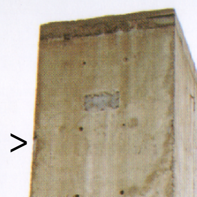 Notice the lengthy chip missing from the left hand side? Now go to 4.52 on the video and look at the same area. There's no missing chip, its flat concrete with a clean edge. This is getting like a discussion about the moon landings.....  |
|
|
|
Post by garethox on Oct 9, 2011 11:31:53 GMT
Do you think we're getting close to a conclusion?  |
|
|
|
Post by Ineedanewname on Oct 9, 2011 13:32:28 GMT
Do you think we're getting close to a conclusion? Well, those moon landing debates have been going on for 4 decades.... Seriously though, I honestly don't know. You could offer me a suitcase containing one million pounds in used notes on the understanding I tell you specifically whether I believe the footage to be of a real or faked location. As things currently stand, I would have to lie to claim that money. Here's the thing. None of the locals (who include mining historians and the local Council) I've recently contacted recognise any place like that in the area of Easington today. Having scrutinised satellite imagery of the vicinity as if I'm working my way through an apprenticeship for the Ordnance Survey, I've seen nowhere of that appearance in the area. Also, there do appear to be minor discrepancies between the monolith pictured on the album cover and the monolith featured in the video. But. Why would somone go to the time - and expense - of not only faking an astoundingly accurate lifesized reproduction of the monolith, but also of the surrounding landscape, simply for a Youtube video? Judging by his previous videos the uploader does have a history in film studies, but this footage would require too much work for any purpose less than a pitch to Hollywood of his version of the Lifehouse movie....surely? Which is why I'm left straddling the fence to the point of suffering intimate pain. |
|
|
|
Post by Nnic on Oct 9, 2011 14:39:55 GMT
Further to my previous answer, I have contacted Peterlee Tourist Info and they are looking into it for us. Funnily enough there was a lady in the shop at the time from Easington and she had never heard of it! I didn't even know they existed. I think you may have found the only place I didn't contact. I have just studied the video again and there are a few things which aren't quite right. At the start when the album cover is in front of the monolith, one can see an angle of approx. 30 degrees halfway down on the left which extends to the middle - sort of where the concrete has been chipped away. On the video monolith this is about 60 degrees and does not extend to the centre. At the top of the monolith there is also a pipe sticking out - on the album cover there seems to be no such pipe. Another thing that caught my eye was at 1.33 - the monolith looks like a drawing or a superimposed image. Intriuging to say the least! I've spotted another oddity. The photo below is an outtake from the 1970 session. You can see the full picture here: www.flickr.com/photos/oddsock/283756588/sizes/o/in/photostream/Notice the lengthy chip missing from the left hand side? Now go to 4.52 on the video and look at the same area. There's no missing chip, its flat concrete with a clean edge. This is getting like a discussion about the moon landings..... I think i spot the missing chip at 1:23? |
|
|
|
Post by Yellow Printer on Oct 9, 2011 14:50:36 GMT
I emailed the video guy but no response. Maybe it's a conspiracy? Slag heaps, grassy knolls, men in black relieving themselves.....The plot thickens
|
|
|
|
Post by Ineedanewname on Oct 9, 2011 15:01:52 GMT
I think i spot the missing chip at 1:23? I believe you are correct! But why does it disappear at 4.53?  It looks like the same side of the block, although admittedly my eyes are by now developing concrete fatigue, so maybe it's a different side of the same block. I think I'm veering toward the opinion the footage is of the actual location, but was filmed prior to the mass clean-up of the area which took place between 1997 and 2002. To give you an idea of the extent of the clean-up; www.durhamheritagecoast.org, "Colliery reclamation sites at Easington and Horden had large cliff edge spoil heaps. In both cases, these heaps were removed and spoil was spread over the sites, capped and covered with soil to create public open space at Easington and for habitat creation at Horden. In total, 1.3 million tonnes of spoil was removed and 80 hectares of land was reclaimed by this process." |
|
tones
Loves that CSI tune
Posts: 5
|
Post by tones on Oct 17, 2011 14:27:05 GMT
About 2 miles north of Easington Colliery there is a wasteland with something that looks just like the monument although it appears to be hollow not solid. Attachments:
|
|
|
|
Post by Ineedanewname on Oct 18, 2011 2:13:16 GMT
I had a reply about this tonight from the Member of Parliament for the area. His opinion matches a couple of others I've had from locals, that it was most likely part of the Easington Colliery aerial ropeway and was removed when the area was cleaned up. So I'm going to stick with my earlier theory that the video footage in question is authentic but dates from a decade ago, and has been intercut in more recent years with faked imagery. I think we can finally call this case closed....as regards the location. If anyone wants to visit the site its probably the northern edge of the colliery (now a field empty field but for a structure marking the old pithead) to which Garerth referred earlier: whochat.proboards.com/index.cgi?action=display&board=GEN&thread=10682&page=2#116810Also, there's a map here showing where the aerial ropeway was: sites.google.com/site/waggonways/nz/40/nz4040 |
|
|
|
Post by Yellow Printer on Oct 18, 2011 17:29:44 GMT
|
|
|
|
Post by whoireland on Oct 18, 2011 18:06:08 GMT
it kinda makes sense it's gone...
my earlier point about if it was real,we'd have seen more pics holds..
even though it was in a hidden location,surely in these days of forums,internet etc, a Who fan who found it would go nuts posting it on the net...
there aren't many other landmarks to recreate a who cover....TKAA maybe?
maybe that would be an interesting side thread....fans recreating famous Who images/poses?
|
|
|
|
Post by chevvies on Feb 13, 2021 22:43:56 GMT
Forgive the late intrusion 
I spent almost a day a few years ago trying to confirm where this shot was actually taken.
Being not far from the Easington area and armed with the album cover I set about to satisfy my curiosity. All the way there I wondered why on earth they would have turned left off the A1(M) and gone six miles further on, to Easington Village through to the Colliery.
I have also read that Pete was driving fast down the M1 with Ethan Russell when he saw the 'monolith', (there where apparently two of them), possibly on the way back down from the Sunderland Top Rank gig road testing the album during a break from the recording sessions, but they would have used the A1(M) in the County Durham area.
The more likely scenario is the gentleman on here who suggested it was Orgeave Colliery in Sheffield S13 area, which would surely be visible from the M1.
Another point, while I was there a gentleman who was curious as to my quest, didn't recall the object(s), he then produced an excellent aerial photo of the area from the late 60's which showed nothing remotely similar.
As I am from near the area I want to believe it, but I don't . Any opinions at this late stage thoroughly welcome. |
|
|
|
Post by bobdylan on Feb 14, 2021 16:54:19 GMT
I always thought that the monolith on the album cover was a reference to the thing from 2001 a space oddessy, which was a big movie at the time.
It is fitting that they are pi**ing on it. An artistic leap that the monolith represents Lifehouse. Townshend's masterpiece Lifehouse doesn't work out so they p**s on it.
|
|


